Planning Services
Planning ensures that Selwyn Township is planned and developed in a manner that meets the existing and future goals of our community.
The Planning Department develops and implements land-use policies, regulations and approvals. Before planning any project, check the list of services and applications on this page. If you have any questions, Planning staff would be happy to assist.
| Pre-Consultation (for Zoning By-Law Amendment or Site Plan Control Agreement only) | ||||||||||||||||||||||||||||||||||||||||||||||||||||||||
|
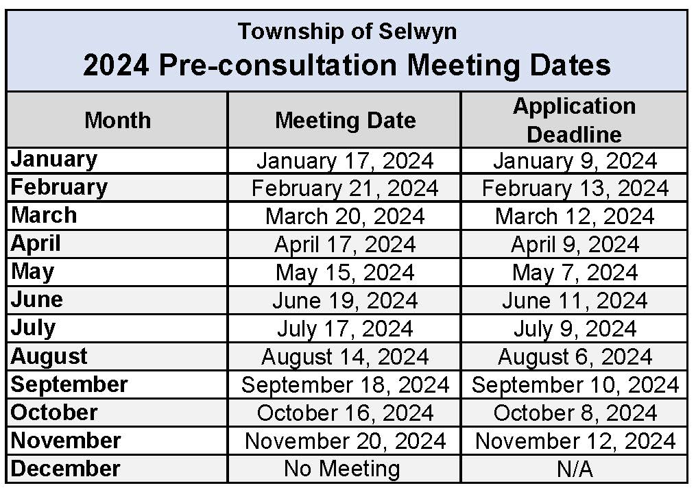
Pre-consultation Forms & Meetings are only for Zoning By-law Amendment or Site Plan Control Agreement applications. If you are looking for a general preliminary review of a site plan please email it to planning@selwyntownship.ca.
Selwyn Township Council passed By-law Number 2016-041 being a by-law to require mandatory pre-consultation with the Township of Selwyn before submitting applications for zoning by-law amendments and site plan approval. What is Pre-consultation? Prior to making an application for a Zoning By-law Amendment, or Site Plan Approval, a pre-consultation meeting with staff is mandatory. Pre-consultation prior to the submission of a formal application can help ensure a complete application and provide opportunities for early feedback on the proposed development plan. It ensures that all relevant planning policies are identified early in the process, as well as ensuring that all the relevant agencies (i.e. ORCA, TSW, PPH) are at the table at the beginning of the development process. It provides the Township with an opportunity to describe the development process and provide the potential applicant with a general idea of the costs and timelines associated with the application(s). |
||||||||||||||||||||||||||||||||||||||||||||||||||||||||
| Selwyn Official Plan | ||||||||||||||||||||||||||||||||||||||||||||||||||||||||
|
An Official Plan sets policies for guiding proper land use and development in the community. The Official Plan outlines where residential, industrial and commercial areas are contemplated. Council undertakes the preparation of the Official Plan with input from the public, ministries and other agencies. When preparing the Official Plan, Council shall be consistent with the Provincial Policy Statement and the Peterborough County Official Plan. Official Plan Amendment (OPA) No. 3 to the County of Peterborough Official Plan received Ministerial consent on October 22, 2008. With the approval of OPA No. 3, the County Official Plan now functions as the lower tier Official Plan for the Township. Includes the following:
|
||||||||||||||||||||||||||||||||||||||||||||||||||||||||
| Selwyn Comprehensive Zoning By-law | ||||||||||||||||||||||||||||||||||||||||||||||||||||||||
A Zoning By-law is a legal document that regulates the use of land within the Township. The By-law determines among other things:
The Zoning By-law must conform to the Official Plan of the Township. A copy is available for viewing in the documents below and at the Municipal Office.
Zoning By-law Amendments The Official Plan outlines in a broad manner the land use and development guidelines within the Township. A Zoning By-law, on the other hand, outlines how a specific parcel of land may be used. Zoning By-laws also regulate lot size, parking requirements, building height and other site-specific factors. If an applicant wishes to develop a property in a manner that deviates from the current zoning provisions, they must apply for a Zoning By-law Amendment; also referred to as a rezoning. For example, a change of use from residential to commercial would require a Zoning By-law Amendment. Township Council must approve any amendment to the Zoning By-law, which is subject to an appeal process. Sometimes a property owner only wants to make a minor deviation to the Zoning By-law provision such as a building setback or height restriction requirements. Owners who want to have minor changes to the use of their property that differ only slightly from Zoning By-law provisions can instead apply to the Committee of Adjustment for what is known as a minor variance. For example, a property owner planning an addition on to their house determines that with the addition there will only be a 6.5 meter rear yard. The Zoning By-law requires a rear yard depth of 7.5 meters. This is a minor deviation, and the owner could apply to the Committee of Adjustment for a minor variance that if approved would relax the rear yard requirement under the Zoning By-law and allow for the addition to proceed. How to apply for a Zoning By-law Amendment? Before making an application, you should discuss your proposal with staff. The application should be submitted to the Building & Planning Department; together with the required fee and any other information that may be required to support the application (usually determined through pre-consultation with Township Staff). What Happens Next? The application will be processed by staff who will circulate it to the required public bodies for comments, as well as to all property owners within 120 metres of the subject site. A sign will be installed on the property briefly describing the proposal. Once all comments have been received, the Township will hold a Public Meeting as per the requirements of the Ontario Planning Act. The Township Planner will prepare a report to Township Council with a recommendation to approve or refuse the rezoning application. You are encouraged to attend the Public Meeting to present your view. If Council approves the proposed amendment, it will pass a by-law which will be circulated to give interested parties the chance to appeal. A 20-day appeal period is provided for, once notice of Adoption of the By-law has been given. If no appeals are received by the end of the appeal period, the amendment is in full force and effect. |
||||||||||||||||||||||||||||||||||||||||||||||||||||||||
| Site Plan Control | ||||||||||||||||||||||||||||||||||||||||||||||||||||||||
| What is Site Plan Control?
Site plan control is a form of development control provided to municipalities by Ontario's Planning Act. No one can undertake any development which is subject to site plan control unless the Township has reviewed and approved certain plans. Once the plans are approved, a site plan agreement is generally executed. This agreement contractually binds the owner to develop and maintain a site in accordance with the approved plans and the terms of the agreement. Building permits are not generally issued until site plan control requirements are addressed. What is the purpose of Site Plan Control? The Site Plan Control process allows Township staff to review and approve the following:
Further, Site Plan Control ensures that Township, County and other agency standards and requirements are met. Pre-consultation with Township Planning Staff Applicants are advised to request a pre-consultation with Township Planning staff, prior to the submission of the application, in order to gain a preliminary planning review and direction. Detailed information of the proposed development, lot characteristics, surrounding land uses and natural features are required at the pre-consultation stage. A failure to participate in pre-consultation may result in processing delays, as Planning staff may be unable to determine the accuracy and completeness of the application. Staff is available to explain the process, indicate the feasibility of the proposed development and may be able to point out any special considerations for the property. Staff may also recommend the applicant consult with other Township staff, the County of Peterborough, the Otonabee Region Conservation Authority and/or any other Ministries and Agencies which may further assist the applicant. |
||||||||||||||||||||||||||||||||||||||||||||||||||||||||
| Minor Variance (Committee of Adjustment) | ||||||||||||||||||||||||||||||||||||||||||||||||||||||||
|
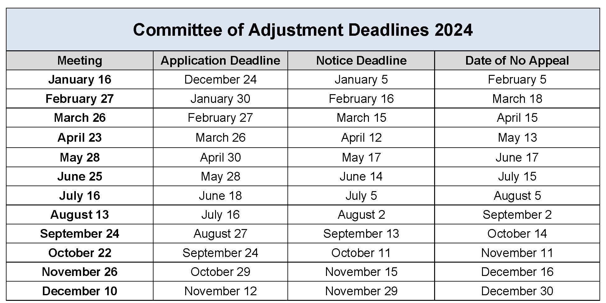
All development proposals must comply with the Township of Selwyn Comprehensive Zoning By-law, which establishes regulations specific to individual properties. These regulations deal with permitted uses, building setbacks, building height, pool and accessory structure requirements, etc. Whenever changes are made to a particular site and any of the regulations are not complied with, a minor variance or an amendment to the Zoning By-law is required to legalize the situation. Potential applicants are encouraged to consult with appropriate Planning Staff prior to applying for a minor variance. A minor variance is a minor deviation (variance) to the provisions of the Zoning Bylaw. The variances can relate to the land, building, or structure of the uses thereof. The Committee of Adjustment is a committee, comprised of Council members, which deals with minor variances and meets once a month. The Committee of Adjustment is authorized to grant minor variances from the Township’s Zoning By-law, and to permit enlargements, extensions or changes to legal nonconforming uses. The Committee of Adjustment have open public meetings and are livestreamed and recorded. Notices are sent to properties within 60 m of the subject lands. Affected residents routinely attend Committee meetings to ask questions and learn more about applications, including potential impacts. The Committee is tasked with approving or denying applications. The Committee regularly asks for condition(s) to be added to ensure that applications meet legislated requirements or to address the concerns of a neighbour or both. Conditions might include a drainage plan, an arborist’s report, a survey or an archeological assessment. All of these conditions have cost implications to the applicant, but the Committee asks for conditions not to be punitive but to meet its legislated requirements or to ensure that there aren’t adverse impacts to area residents.
|
||||||||||||||||||||||||||||||||||||||||||||||||||||||||
| Land Severance | ||||||||||||||||||||||||||||||||||||||||||||||||||||||||
|
A land severance (also known as a consent) is the division of your land, which creates separate parcels. The Selwyn Official Plan has specific requirements and/or conditions for land severances. Being approved for a land severance depends on lot size, compatibility, public and private roads, conformity to the Official Plan and the Zoning By-law, water supply, sewage disposal, etc.
|
||||||||||||||||||||||||||||||||||||||||||||||||||||||||
| Floodplain Mapping | ||||||||||||||||||||||||||||||||||||||||||||||||||||||||
What is a floodplain map? During a flood, water levels rise. Areas not normally covered by water may be inundated. This could be because of land elevation, jams of ice and debris, and built development features such as pavement and houses. Floodplain maps use data and technical models to predict the path of floodwaters – the area known as the floodplain. It is important to remember that a floodplain map does not create a flooding hazard; it simply shows where the flooding hazard is. Why is it important to protect and respect floodplains? Floodplain mapping is a tool to protect and respect the floodplain. Flooding poses dangers to people and property. Knowing the extent of the floodplain is critical to reducing potential property damage and risks to public safety, environmental protection and emergency management. Effective floodplain management is a key goal of Otonabee Conservation. How does floodplain mapping affect me? Floodplain maps help protect property and human life. There are planning documents that are used to guide decisions about land use and development. The floodplain map helps to determine where new buildings may be located, if the property in question is at risk during a flood or storm event. In some cases, it may be necessary for property owners to take measures to protect existing buildings from flooding. Floodplain mapping helps us to direct development away from areas that put people, properties, and the environment at risk. |
||||||||||||||||||||||||||||||||||||||||||||||||||||||||
| Archeological Assessments | ||||||||||||||||||||||||||||||||||||||||||||||||||||||||
|
Applications for Minor Variances are regulated by the Ontario Planning Act. As a Minor Variance application is an application under the Planning Act, the Committee of Adjustment is compelled to make planning decisions that conform with the Provincial Policy Statement (PPS). As it relates to the Township's legislated responsibility related to the completion of an archaeological assessment, the Provincial Policy Statement provides direction:
The specific requirements for when an archeological assessment is to be completed is governed through the Ministry of Tourism, Culture and Sport (MTCS). The has been longstanding practice to require archeological assessments for larger developments (plans of subdivision and condominiums). Moving forward, to achieve compliance with the PPS and MTCS smaller developments, including applications for a minor variance must also consider the need for an archaeological study. Each application for a minor variance is evaluated against the MTCS checklist to determine if an archeological assessment needs to be completed OR not. |
||||||||||||||||||||||||||||||||||||||||||||||||||||||||
| Planning Forms | ||||||||||||||||||||||||||||||||||||||||||||||||||||||||
| Visit the Forms, Applications, Permits page | ||||||||||||||||||||||||||||||||||||||||||||||||||||||||
| Planning Fees | ||||||||||||||||||||||||||||||||||||||||||||||||||||||||
|
||||||||||||||||||||||||||||||||||||||||||||||||||||||||
| Current Planning Applications | ||||||||||||||||||||||||||||||||||||||||||||||||||||||||
|
For Building related services, visit the Building Services page.
Contact Us


